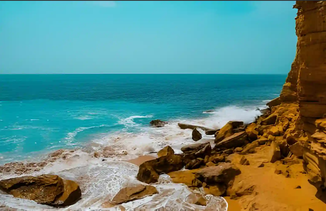
Gwadar, perched on the southwestern edge of Pakistan’s Balochistan province, is a city where the desert meets the sea—and where history, commerce, and natural beauty converge. Once a quiet fishing village, Gwadar has transformed into a strategic port city with global significance. Its crescent-shaped coastline, turquoise waters, and volcanic cliffs make it one of the most visually stunning destinations in South Asia. But Gwadar is more than a postcard-perfect landscape—it’s a symbol of Pakistan’s future.
Historical Background
Gwadar’s history stretches back millennia. Archaeological evidence suggests that the region was part of ancient trade routes connecting Mesopotamia, the Indus Valley, and the Persian Gulf. The name “Gwadar” is believed to derive from the Persian “Gwat Dar,” meaning “gateway of winds.”
For centuries, Gwadar remained under the control of various regional powers, including the Omani Sultanate. In fact, Oman ruled Gwadar until 1958, when Pakistan purchased the territory and formally integrated it into Balochistan. This unique historical connection has left cultural imprints in architecture, language, and local customs.
The city’s strategic location—at the mouth of the Arabian Sea and near the Strait of Hormuz—has long made it a point of interest for maritime powers. But it wasn’t until the early 2000s that Gwadar began its transformation into a modern port city, catalyzed by the development of the China-Pakistan Economic Corridor (CPEC).
Geographical Significance
Gwadar sits at the junction of three major regions: South Asia, Central Asia, and the Middle East. Its proximity to the Persian Gulf and the Strait of Hormuz gives it immense geopolitical value. The city is located approximately 650 kilometers west of Karachi and 120 kilometers from the Iranian border.
The terrain is a dramatic mix of coastal plains, volcanic hills, and desert expanses. The Hammerhead Peninsula, formed by ancient lava flows, juts into the Arabian Sea like a natural fortress. Inland, the Makran Coastal Range rises in jagged formations, offering panoramic views and geological intrigue.
Gwadar’s deep-sea port is naturally sheltered, making it ideal for large cargo ships and naval vessels. This geographic advantage has positioned Gwadar as a future hub for international shipping, trade, and logistics.
Cultural Context
Gwadar’s population is a tapestry of Baloch tribes, fishermen, traders, and settlers from across Pakistan. The dominant language is Balochi, though Urdu and Pashto are also spoken. The city’s cultural identity is shaped by its coastal lifestyle, tribal traditions, and spiritual heritage.
Fishing remains a central part of daily life, with colorful boats dotting the harbor and fresh seafood served in homes and markets. Music, poetry, and storytelling are integral to Baloch culture, often performed during festivals and community gatherings.
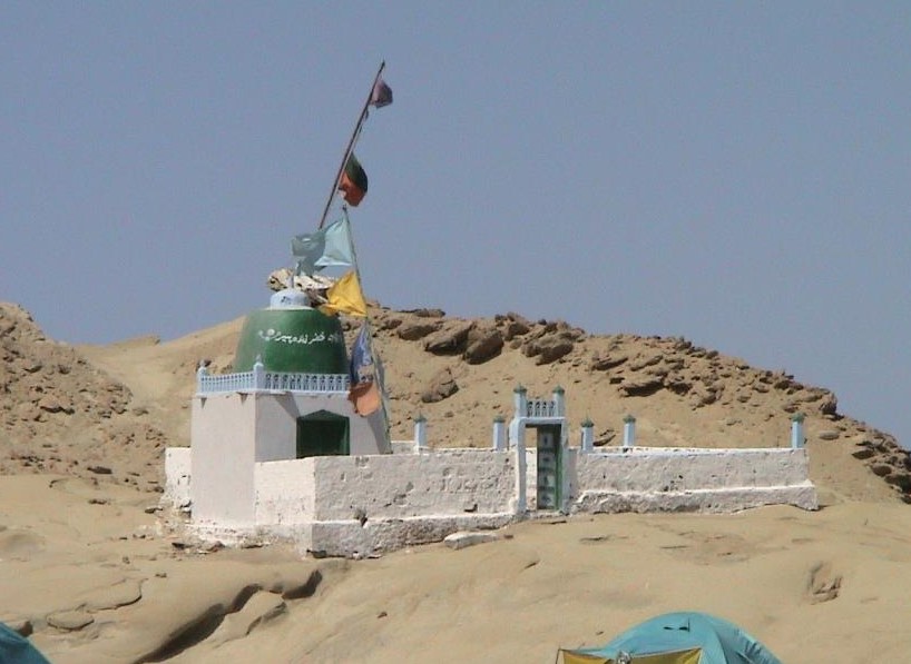
Religious life centers around mosques and shrines, with Sufi influences visible in local rituals and architecture. The city’s spiritual landscape includes sites like the Shrine of Hazrat Baba Chand, which draws pilgrims from across the region.
Strategic Importance
Gwadar is the centerpiece of CPEC, a multi-billion-dollar initiative that connects China’s western provinces to the Arabian Sea. The Gwadar Port is being developed in collaboration with Chinese firms, with infrastructure projects including highways, rail links, and energy corridors.
This strategic investment has elevated Gwadar’s status on the global stage. The port is envisioned as a gateway for trade between China, Central Asia, and the Middle East, bypassing traditional routes through the Strait of Malacca. For Pakistan, Gwadar represents economic diversification, regional integration, and geopolitical leverage.
Military and naval installations have also expanded in the region, underscoring Gwadar’s role in maritime security and regional defense.
Economic Potential
Gwadar’s economic future is anchored in its port, but its potential extends far beyond shipping. The city is being developed as a Special Economic Zone (SEZ), offering tax incentives and infrastructure support for investors. Real estate, tourism, fisheries, and energy are emerging sectors with high growth potential.
Tourism, in particular, is gaining momentum. With its pristine beaches, dramatic landscapes, and cultural richness, Gwadar is attracting travelers seeking off-the-beaten-path experiences. The government and private sector are investing in hotels, resorts, and eco-tourism initiatives to support this growth.
Gwadar also holds promise for marine research, aquaculture, and renewable energy—especially solar and wind—thanks to its climate and geography.
Transportation in Gwadar
Gwadar’s strategic location on Pakistan’s southwestern coast makes it a gateway to the Arabian Sea and a vital node in regional connectivity. Whether you’re arriving from Karachi, Quetta, or further afield, Gwadar offers multiple transportation options—each with its own advantages and logistical considerations. From scenic coastal drives to expanding air links, getting to Gwadar is part of the adventure.
Reaching Gwadar by Air
Gwadar is served by Gwadar International Airport (GWD), located approximately 12 kilometers northeast of the city center. The airport currently handles domestic flights, with regular service from:
- Karachi (KHI): Daily flights via Pakistan International Airlines (PIA)
- Islamabad (ISB): Limited weekly flights
- Turbat (TUK): Regional connections
The airport is undergoing a major upgrade under CPEC, with the New Gwadar International Airport expected to be operational soon. This facility will accommodate wide-body aircraft and international flights, positioning Gwadar as a global aviation hub.
- Airport amenities: Basic terminal services, car rentals, and shuttle access
- Travel tip: Book flights early, as seat availability can be limited during peak seasons
Road Transportation
Gwadar is accessible via the Makran Coastal Highway (N-10), a scenic and well-paved route that connects Karachi to Gwadar through the towns of Hub, Kund Malir, Ormara, and Pasni. The drive from Karachi takes approximately 8 hours, offering breathtaking views of the Arabian Sea, Hingol National Park, and golden beaches along the way.
Alternate road routes include:
- From Quetta: Via N-85 and M-8 highways, passing through Surab, Panjgur, and Turbat
- From Turbat: A 2-hour drive via the RCD Highway
Bus services such as Al Mumtaz Coaches operate luxury Yutong and Daewoo buses between Karachi, Turbat, and Gwadar, offering comfortable and affordable travel options. Online booking is available through platforms like and .
- Fare estimate: PKR 2,500 from Karachi to Gwadar
- Travel tip: Choose executive or sleeper class for long-distance comfort
Railway Connectivity
Gwadar currently lacks a functional railway station. However, under CPEC and Pakistan Railways’ long-term plans, a proposed rail link will connect Gwadar to Quetta and further to the national rail network. Until then, travelers arriving by train to Karachi or Quetta must transition to road or air transport.
- Nearest railheads: Karachi Cantt Station, Quetta Railway Station
- Travel tip: Combine train and bus travel for budget-friendly itineraries
Sea Access
As a port city, Gwadar is accessible by sea, though passenger services are limited. The Gwadar Port primarily handles cargo and commercial vessels. Private yachts and research vessels occasionally dock, but there is no regular ferry service for tourists.
Future plans include developing marinas and cruise terminals, which could open new avenues for coastal tourism and international arrivals.
- Travel tip: Contact port authorities for special permissions if arriving by private vessel
Local Transportation Within Gwadar
Navigating Gwadar is straightforward, with several local transport options:
- Rickshaws: Widely available and affordable for short distances
- Taxis: Operate on fixed or negotiable fares; ideal for airport transfers and sightseeing
- Car Rentals: Available through hotels and local agencies; recommended for independent exploration
- Motorbikes: Common among locals; rentals possible through informal arrangements
Walking is feasible in central areas like Marine Drive, Jinnah Avenue, and the Old City, especially during cooler months. However, due to heat and elevation, long walks should be avoided midday.
- Mobile coverage: Strong in urban zones; patchy in remote areas
- Navigation: Use offline maps or local guides for rural exploration
Travel Tips and Recommendations
- Fuel and Supplies: Fuel stations are available along major routes; stock up before entering remote stretches
- Weather Considerations: Travel during cooler months (October–March) for comfort and safety
- Security: Gwadar is generally safe, but travelers should stay informed and avoid isolated areas after dark
- Permits: Foreign travelers may require a No Objection Certificate (NOC) to visit Balochistan
Gwadar’s transportation network is evolving rapidly. With proper planning and local insight, the journey to and within Gwadar becomes a rewarding part of the travel experience—whether you’re chasing sunsets, scouting investment opportunities, or documenting coastal heritage.
Top Attractions In Gawadar
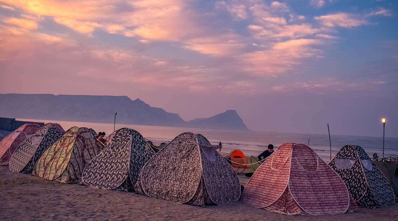
Gwadar Beach
Gwadar Beach is the soul of the city—a sweeping stretch of golden sand that curves gently along the Arabian Sea, offering tranquility, breathtaking views, and a front-row seat to nature’s rhythm. Unlike the crowded beaches of urban Pakistan, Gwadar Beach remains largely untouched, making it a sanctuary for
, reflection, and raw beauty.
Geographical and Visual Appeal
Located just minutes from the city center, Gwadar Beach spans several kilometers along the southern coast. Its crescent shape mirrors the city’s coastline, with soft sand dunes on one side and calm, turquoise waters on the other. The beach is framed by volcanic hills and the iconic Hammerhead Peninsula, creating a dramatic backdrop for sunrise and sunset photography.
The water here is unusually clear, often reflecting shades of emerald and sapphire depending on the time of day. Gentle waves lap against the shore, and the absence of commercial noise makes the beach ideal for meditation, stargazing, and long walks.
Activities and Experiences
Gwadar Beach offers a range of low-impact, nature-based activities:
- Swimming and Wading: The shallow waters near the shore are safe for swimming, especially during low tide.
- Picnicking: Families and groups often gather under makeshift tents or palm shades to enjoy local snacks and seafood.
- Photography: The beach is a dream for photographers—sunrise over the water, silhouettes against the hills, and reflections in tide pools.
- Birdwatching: Sea birds, including herons, gulls, and migratory species, frequent the area.
- Dolphin Spotting: On quiet mornings, dolphins are occasionally seen near the harbor, especially during winter months.
While there are no formal water sports facilities yet, local entrepreneurs offer boat rides and guided shoreline tours during peak seasons.
Accessibility and Amenities
Gwadar Beach is easily accessible via Marine Drive, a well-maintained coastal road that runs parallel to the shoreline. Visitors can reach the beach by:
- Rickshaw or Taxi: Widely available in the city; fares range from PKR 200–500 depending on distance.
- Private Vehicle: Parking is available along Marine Drive and adjacent streets.
- Walking: Ideal for those staying in nearby hotels or guesthouses.
Amenities are limited but improving. Public restrooms, shaded seating areas, and food stalls are available near the main entrance. Visitors should bring their own towels, sunscreen, and drinking water.
- Best time to visit: October to March for cooler weather and clear skies.
- Entry fees: None
- Safety tips: Avoid swimming during high tide or stormy weather; keep valuables secure.
Photography Tips
Gwadar Beach offers exceptional opportunities for both landscape and lifestyle photography:
- Golden Hour: Capture the warm glow of sunrise or sunset reflecting off the water.
- Silhouettes: Use the volcanic hills and fishing boats as dramatic foregrounds.
- Reflections: Tide pools and wet sand create mirror-like surfaces.
- Wildlife: Zoom lenses are ideal for capturing birds and marine life.
Drone photography is permitted with local approval and offers stunning aerial views of the crescent-shaped coastline and surrounding cliffs.
Cultural Significance
For the people of Gwadar, the beach is more than a leisure spot—it’s a source of livelihood and identity. Fishermen launch their boats from nearby wharfs, children play in the surf, and elders gather to share stories of the sea. Traditional Balochi songs often reference the ocean, and festivals like Eid and Baloch Cultural Day see increased activity along the shore.
The beach also serves as a venue for community events, poetry readings, and spiritual gatherings, reinforcing its role as a cultural anchor.
Conservation and Future Development
Gwadar Beach is part of the city’s broader eco-tourism vision. Local authorities and NGOs are working to preserve its natural integrity while introducing sustainable tourism infrastructure. Plans include:
- Eco-lodges and beachfront resorts
- Waste management and recycling initiatives
- Marine conservation zones
Visitors can support these efforts by respecting the environment, avoiding littering, and engaging with local businesses.
Hammerhead Peninsula
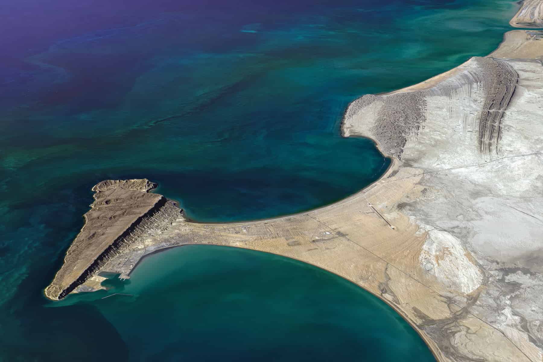
The Hammerhead Peninsula is Gwadar’s most striking natural landmark—a dramatic, flat-topped landmass jutting into the Arabian Sea that resembles the head of a hammer when viewed from above. This unique geological formation is not only a visual marvel but also a symbol of Gwadar’s ancient volcanic history and strategic coastal geography.
Geological Origins
The Hammerhead Peninsula is a classic example of a horst, a block of the Earth’s crust that has been uplifted while the surrounding land sank. It was formed by mud volcano eruptions along the Makran Coast, a tectonically active region where the Arabian Plate collides with the Eurasian Plate. These eruptions created the peninsula’s flat surface and steep cliffs, giving it its distinctive hammerhead shape.
The peninsula is flanked by two natural bays—Paddi Zirr to the east and Demi Zirr to the west—making it an ideal location for port development and maritime navigation. Its geological stability and elevation have made it a focal point for both tourism and strategic infrastructure.
Scenic and Strategic Importance
From the southern edge of the Hammerhead Peninsula, visitors are treated to sweeping views of the Arabian Sea, where the horizon stretches endlessly and the water glows in shades of blue and green. On the northern side, the peninsula offers panoramic views of Gwadar city, including the bustling port, Marine Drive, and the expanding skyline.
The Pearl Continental Hotel, perched on the slopes of Koh-e-Batil—one of the peninsula’s twin hills—is a popular vantage point for sunrise and sunset photography. A steep stairway carved into the mountain leads to the summit, offering one of the most breathtaking views in all of Balochistan.
Activities and Experiences
The Hammerhead Peninsula is ideal for:
- Hiking: Trails around Koh-e-Batil and Koh-e-Mehdi offer moderate climbs and stunning views.
- Photography: Capture aerial-like shots of the coastline, city, and sea from elevated points.
- Sightseeing: Visit the Pearl Continental viewpoint, the old town of Gwadar, and nearby fishing docks.
- Birdwatching: Spot migratory birds and sea eagles that nest along the cliffs.
While there are no formal tour operators yet, local guides and hotel staff often assist visitors with directions and safety tips.
Accessibility and Amenities
The Hammerhead Peninsula is easily accessible from central Gwadar:
- By car or taxi: A 10–15 minute drive from Marine Drive or the city center.
- By foot: Adventurous travelers can hike from nearby neighborhoods to the base of Koh-e-Batil.
- Parking: Available near the Pearl Continental Hotel and designated viewpoints.
Amenities include shaded seating areas, restrooms at the hotel, and food stalls along Marine Drive. Visitors should bring water, sun protection, and sturdy footwear.
- Best time to visit: October to March for cooler weather and clear skies.
- Entry fees: None; hotel access may require booking or permission.
- Safety tips: Avoid cliff edges during windy conditions; stay hydrated during hikes.
Photography Tips
- Golden Hour: Capture the peninsula’s silhouette against the rising or setting sun.
- Wide-Angle Shots: Use panoramic lenses to frame the coastline and cityscape.
- Aerial Perspective: Drone photography (with permission) reveals the full hammerhead shape.
- Detail Shots: Focus on rock textures, erosion patterns, and sea reflections.
The peninsula’s elevation and natural symmetry make it one of the most photogenic spots in Gwadar.
Cultural and Symbolic Value
Locals regard the Hammerhead Peninsula as a symbol of Gwadar’s resilience and transformation. It has featured in poetry, songs, and political speeches as a metaphor for strength and vision. The twin hills—Koh-e-Batil and Koh-e-Mehdi—are often referenced in Balochi folklore and spiritual narratives.
During festivals and national holidays, the area around the peninsula becomes a gathering place for families, artists, and community leaders. Its presence in local art and storytelling reinforces its role as a cultural landmark.
Koh-e-Batil
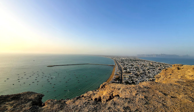
Rising 470 feet above sea level on the southern edge of Gwadar, Koh-e-Batil is more than just a hill—it’s a vantage point, a spiritual retreat, and a symbol of the city’s evolving identity. Perched on the Hammerhead Peninsula, this natural elevation offers unmatched views of Gwadar’s crescent-shaped coastline, bustling port, and the vast Arabian Sea. For travelers, photographers, and spiritual seekers, Koh-e-Batil is a must-visit destination that combines adventure with awe.
The Ascent
Reaching the summit of Koh-e-Batil is part of the experience. Visitors can ascend via:
- Stone Stairway: A winding path of approximately 700 steps, built specifically for pedestrians. The climb is moderate and includes two resting points, making it accessible for most fitness levels.
- Vehicular Route: A rough but navigable road allows access by car or motorbike. This option is suitable for those who prefer a less strenuous journey.
Whether you hike or drive, the journey is a prelude to the breathtaking views that await at the top.
Panoramic Views
From the summit, the landscape unfolds in every direction:
- To the South: The Arabian Sea stretches endlessly, its waters shimmering in hues of blue and green.
- To the North: Gwadar city lies below, with its expanding skyline, port infrastructure, and winding roads.
- To the East and West: The twin bays—Paddi Zirr and Demi Zirr—frame the peninsula, enhancing the hammerhead shape that defines Gwadar’s geography.
Sunrise and sunset are particularly magical, casting golden light across the hills and sea. The view from Koh-e-Batil is often described as surreal—a moment where time seems to pause.
Activities and Experiences
Koh-e-Batil offers a range of experiences:
- Photography: Capture wide-angle shots of the coastline, cityscape, and sea. Drone photography (with permission) reveals the full hammerhead shape of the peninsula.
- Meditation and Reflection: The summit’s quiet atmosphere makes it ideal for spiritual retreats and personal reflection.
- Sightseeing: Visit the nearby Pearl Continental Hotel, which offers luxury accommodations and a viewing deck.
- Trekking: The stairway trek is a favorite among adventure seekers, especially during early morning or late afternoon.
Local guides are available to assist with navigation, storytelling, and safety tips.
Accessibility and Amenities
Koh-e-Batil is located just 10–15 minutes from Gwadar’s city center:
- By Rickshaw or Taxi: Widely available; fares range from PKR 300–600.
- By Private Vehicle: Parking is available near the base and at the Pearl Continental Hotel.
- On Foot: Ideal for those staying nearby or seeking a full trekking experience.
Amenities include shaded seating areas, restrooms at the hotel, and food stalls along Marine Drive. Visitors should bring water, sun protection, and comfortable footwear.
- Best time to visit: October to March for cooler temperatures and clear skies.
- Entry fees: None; hotel access may require booking or permission.
- Safety tips: Avoid cliff edges during windy conditions; stay hydrated during hikes.
Cultural and Spiritual Significance
Koh-e-Batil holds a special place in local culture. It’s often referenced in Balochi poetry and songs as a symbol of resilience and perspective. The hill is also associated with spiritual practices, with locals visiting the summit for prayer, reflection, and storytelling.
During festivals and national holidays, Koh-e-Batil becomes a gathering place for families, artists, and community leaders. Its presence in local art and oral history reinforces its role as a cultural landmark.
Gwadar Cricket Stadium
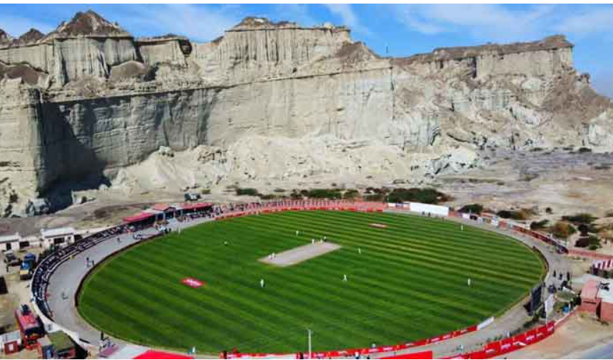
Nestled between rugged limestone hills and the shimmering Arabian Sea, Gwadar Cricket Stadium—officially known as the Senator Muhammad Ishaq Baloch Cricket Stadium—has earned global acclaim as one of the most beautiful cricket venues in the world. Its surreal backdrop and coastal serenity make it a must-visit destination for sports enthusiasts, photographers, and travelers seeking a unique blend of nature and culture.
Location and Layout
Located in Gzar Ward, near Gwadar Port Road, the stadium sits at the base of rocky cliffs that rise dramatically behind the lush green field. The contrast between the arid mountains and the manicured pitch creates a visual spectacle that has captivated audiences worldwide. The stadium’s coordinates—25.1111°N, 62.3227°E—place it squarely within Gwadar’s scenic corridor.
Though modest in size, the stadium’s design maximizes its natural surroundings. There are no towering stands or concrete walls—just open views, clean lines, and the uninterrupted beauty of Balochistan’s terrain.
Global Recognition
In early 2021, the International Cricket Council (ICC) shared images of the stadium on social media, calling it “breathtakingly beautiful” and challenging followers to find a more scenic venue. The post went viral, drawing praise from cricket fans, travel bloggers, and international media outlets.
The stadium hosted its first official match in February 2021, a local fixture that marked a new chapter in Gwadar’s sporting history. Since then, it has become a symbol of Balochistan’s potential to host national and international events.
Activities and Experiences
Visitors to Gwadar Cricket Stadium can:
- Attend Local Matches: The stadium hosts domestic competitions and youth tournaments, including the planned Balochistan Under-19 League.
- Take Guided Tours: Local guides and stadium staff offer informal tours, sharing insights into the venue’s history and future plans.
- Enjoy Photography: Capture the stadium’s stunning backdrop, especially during golden hour when the cliffs glow in warm hues.
- Explore Surroundings: Combine your visit with a walk along Gwadar Port Road or a stop at nearby viewpoints.
While the stadium is not yet equipped for large-scale international matches due to its size (approx. 66 meters in diameter), plans are underway to expand seating and facilities.
Accessibility and Amenities
The stadium is easily accessible from central Gwadar:
- By Rickshaw or Taxi: A 10-minute ride from Marine Drive or the city center; fares range from PKR 200–400.
- By Foot or Bike: Ideal for those staying nearby or exploring the port area.
Amenities include shaded seating, restrooms, and snack vendors during match days. Visitors should bring water, sun protection, and cameras.
- Best time to visit: October to March for cooler weather and active match schedules.
- Entry fees: None for casual visits; ticketed entry during official matches.
- Safety tips: Respect match boundaries and avoid climbing nearby cliffs without guidance.
Photography Tips
- Wide-Angle Shots: Frame the stadium against the cliffs and sky.
- Golden Hour: Capture warm tones and long shadows for dramatic effect.
- Action Shots: Use fast shutter speeds to photograph players in motion.
- Drone Views: With permission, aerial shots reveal the stadium’s full setting between sea and mountains.
The stadium’s natural lighting and open design make it ideal for both amateur and professional photography.
Cultural and Symbolic Value
Gwadar Cricket Stadium is more than a sports venue—it’s a symbol of pride, unity, and aspiration. For local youth, it represents opportunity and visibility. For the city, it’s a statement of readiness to host the world.
During festivals and national holidays, the stadium becomes a gathering place for families, artists, and community leaders. Its presence in local media, music, and storytelling reinforces its role as a cultural landmark.
Ormara Beach
Located midway between Karachi and Gwadar along the Makran Coastal Highway, Ormara Beach is a serene stretch of coastline that offers travelers a peaceful retreat from urban life. With its turquoise waters, golden sands, and dramatic mountain backdrop, Ormara is one of Balochistan’s most underrated gems—perfect for beach lovers, history buffs, and road trip adventurers.
Historical Significance
Ormara’s roots run deep. The town is mentioned in the ancient maritime guide Periplus of the Erythraean Sea as “Oraea,” and its strategic location made it a stopover for traders and conquerors. According to local legend, Alexander the Great passed through Ormara in 400 BC on his return from the Indus Valley. One of his generals, Ormoz, died here, and the town was named in his honor.
For centuries, Ormara was a battleground between Baloch tribal leaders and foreign invaders. It was once part of the State of Lasbela and later integrated into the Makran Division in 1975. Today, it’s home to the Jinnah Naval Base, a key installation of the Pakistan Navy, which has helped stabilize and develop the region.
Natural Beauty and Landscape
Ormara Beach is framed by rugged cliffs and the vast Arabian Sea. The coastline is clean, quiet, and largely untouched by commercial development. The beach stretches for several kilometers, offering ample space for walking, swimming, and photography.
The water here is calm and clear, with gentle waves ideal for wading and boating. The surrounding hills add a dramatic contrast, especially during sunrise and sunset when the light casts golden hues across the landscape.
Nearby attractions include:
- Princess of Hope and Balochistan Sphinx: Natural rock formations located east of Ormara
- Chandragup Mud Volcano: A sacred site for Hindu pilgrims
- Kund Malir Beach: Another scenic stop along the coastal highway
These sites make Ormara a perfect base for exploring the Makran coast.
Activities and Experiences
Ormara Beach is ideal for:
- Camping: Set up tents along the shore and fall asleep to the sound of waves
- Swimming and Wading: Safe and enjoyable during low tide
- Photography: Capture stunning seascapes, cliffs, and starry night skies
- Fishing: Join local fishermen or try your hand at shore fishing
- Boating: Small boats are available for hire through local contacts
Tour operators offer beach huts, resort stays, and guided tours, especially for weekend trips from Karachi.
Accessibility and Amenities
Ormara is located approximately:
- 344 km west of Karachi
- 230 km east of Gwadar
The drive along the Makran Coastal Highway is smooth and scenic, taking about 6–7 hours from Karachi. The road hugs the coastline, offering views of cliffs, beaches, and desert landscapes.
- Transport options: Private cars, tour buses, and rental services
- Accommodation: Beach huts, guesthouses, and naval guest facilities
- Food: Local seafood, snacks, and traditional Balochi dishes
- Mobile coverage: Available but may be patchy in remote zones
- Best time to visit: February to April and July to October
- Safety: The presence of the Jinnah Naval Base ensures security; Ormara is considered safe for families and solo travelers
Photography Tips
- Golden Hour: Capture warm tones on the cliffs and water
- Long Exposure: Use for wave motion and night skies
- Drone Shots: With permission, aerial views reveal the beach’s scale and surrounding terrain
- Portraits: Document local fishermen, boats, and cultural scenes
Ormara’s natural lighting and open vistas make it a dream for landscape photographers.
Cultural and Local Life
Ormara is home to approximately 40,000 residents, with a mix of Sunni and Zikri Muslims. Fishing is the primary livelihood, and the town retains a traditional character despite recent development. Visitors can engage with locals, learn about maritime traditions, and enjoy authentic Balochi hospitality.
The town’s slow pace, spiritual heritage, and connection to the sea make it a place of reflection and discovery.
Gwadar Port
Gwadar Port is more than a maritime facility—it’s the beating heart of Pakistan’s coastal ambitions and a symbol of regional transformation. Strategically located on the Arabian Sea near the Strait of Hormuz, this deep-sea port is the centerpiece of the China-Pakistan Economic Corridor (CPEC) and a gateway to global trade. For travelers, researchers, and investors, Gwadar Port offers a rare glimpse into the intersection of geopolitics, infrastructure, and coastal beauty.
Strategic and Economic Importance
Gwadar Port was inaugurated in 2007 and is operated by the China Overseas Port Holding Company since 2013. It’s designed to serve as a logistics hub for China, the Middle East, Central Asia, and beyond—offering an alternative to the congested Strait of Malacca. The port’s location allows Chinese goods to bypass long sea routes and reach markets via land through Pakistan’s highway and rail networks.
As part of CPEC, Gwadar Port is linked to a network of roads, energy projects, and Special Economic Zones (SEZs). These developments aim to boost Pakistan’s economy, create jobs, and attract foreign investment. The port is also envisioned as a transit hub for Afghanistan and the Central Asian Republics.
Visual and Experiential Appeal
Despite its industrial role, Gwadar Port is visually stunning. The hammerhead-shaped promontory on which it sits offers panoramic views of the Arabian Sea, docked ships, and surrounding cliffs. Visitors can observe port operations from designated viewing areas or photograph the harbor from nearby vantage points like Koh-e-Batil.
Activities around the port include:
- Viewing docked ships and cargo operations
- Photographing the coastline and hammerhead promontory
- Walking along Marine Drive for scenic coastal views
- Exploring nearby parks like GDA Beach Model Park and Padizer Park
- Visiting Zalzala Jazeera, an island formed by a 2013 earthquake
While the port itself lacks tourist infrastructure (no food, water, or restrooms on-site), its surroundings offer plenty of opportunities for exploration and relaxation.
Accessibility and Amenities
Gwadar Port is located approximately 629 km from Karachi, accessible via the Makran Coastal Highway. It’s a short drive from Gwadar city center and Marine Drive.
- By car or taxi: 10–15 minutes from central Gwadar
- By foot: Possible from nearby hotels and parks
- Parking: Available near Marine Drive and viewing areas
Amenities are limited at the port itself, but nearby areas offer food stalls, restrooms, and shaded seating. Visitors should bring water, sun protection, and cameras.
- Best time to visit: October to April for clear skies and active port operations
- Entry fees: None for public viewing zones
- Safety tips: Stay within designated areas; avoid restricted zones without permission
Photography Tips
- Golden Hour: Capture the port’s silhouette against the sea and sky
- Wide-Angle Shots: Frame the hammerhead promontory and docked vessels
- Detail Shots: Focus on cranes, containers, and fishing boats
- Aerial Views: Drone photography (with approval) reveals the port’s layout and strategic position
Nearby Sunset Park offers one of the best vantage points for evening shots of the Arabian Sea.
Cultural and Local Impact
Gwadar Port has reshaped the city’s identity. While it promises economic growth, it has also sparked debates around inclusivity, environmental sustainability, and local livelihoods. Fishermen, traders, and artisans have voiced concerns over access to coastal areas and water scarcity.
Nonetheless, the port has generated demand for hotels, tour guides, and regional goods—benefiting tourism and manufacturing sectors. Markets in Gwadar town offer Balochi embroidery, seafood, and local snacks, making the port area a blend of commerce and culture.
Astola Island (Haft Talar – Island of the Seven Hills)
Astola Island, also known locally as Haft Talar (“Island of the Seven Hills”), is Pakistan’s largest offshore island and a designated Marine Protected Area. Located approximately 39 kilometers southeast of Pasni in Gwadar District, this uninhabited island is a surreal blend of rugged cliffs, coral reefs, and turquoise waters. For eco-tourists, marine researchers, and adventure seekers, Astola offers a rare opportunity to experience nature in its purest form.
Geography and Landscape
Astola spans roughly 6.7 square kilometers, with a length of 6.7 km and a maximum width of 2.3 km. The island rises steeply from the sea, with its highest point reaching 246 feet above sea level. The northern face features dramatic cliffs, while the southern side slopes gently into the sea.
The terrain includes:
- A tilted plateau with seven distinct hillocks
- Deep crevices and natural caves
- Rocky beaches and coral-lined shores
- Sparse vegetation dominated by hardy shrubs like Prosopis juliflora
There is no source of fresh water on the island, and all vegetation relies on rainfall and soil moisture.
Marine Biodiversity and Ecology
Astola Island is a sanctuary for marine and avian life:
- Endangered turtles: Green turtles and hawksbill turtles nest on its beaches
- Birdlife: Breeding grounds for coursers, curlews, godwits, gulls, plovers, and sanderlings
- Reptiles: Home to endemic species like the Astola viper
- Coral reefs: Surround the island, supporting fish, crustaceans, and marine flora
In 2017, Astola was declared Pakistan’s first Marine Protected Area, fulfilling international obligations under the Convention on Biological Diversity.
Historical and Cultural Significance
Astola’s earliest mention dates back to 325 BC, in Arrian’s account of Admiral Nearchos, who was dispatched by Alexander the Great to explore the Arabian Sea coast. The island was feared by sailors for its isolation and eerie legends, often referred to as Nosala in ancient texts.
Local mythology links Astola to Saint Khidr, the mystical “saint of waters,” and the island is considered sacred by some coastal communities. Its spiritual aura adds depth to its natural mystique.
Activities and Experiences
Astola is a dream destination for eco-tourism and adventure:
- Camping: Overnight stays require tents and full provisions
- Snorkeling and Diving: Explore coral reefs and underwater life
- Fishing: Popular among locals and tourists
- Turtle Watching: Observe nesting sites during breeding season
- Photography: Capture dramatic landscapes, marine life, and starry skies
There are no permanent facilities on the island—visitors must bring food, water, and camping gear. Responsible tourism practices are essential to preserve its fragile ecosystem.
Accessibility and Travel Logistics
Astola Island is accessible only by sea:
- Departure point: Pasni, a coastal town in Gwadar District
- Boat type: Motorized fishing boats or chartered vessels
- Travel time: Approximately 3–5 hours depending on sea conditions
- Distance from Gwadar: About 153 km; travelers must first reach Pasni by road
- Best time to visit: October to April for calm seas and mild weather
- Permits: No formal permits required, but coordination with local authorities is advised
- Safety tips: Travel in groups, carry GPS and emergency supplies, and avoid monsoon season
Photography Tips
- Aerial Shots: Drone views reveal the island’s seven hillocks and coral fringes
- Golden Hour: Capture warm tones on cliffs and water
- Underwater Photography: Use waterproof gear for reef and marine life
- Night Skies: Astola’s isolation offers stunning astrophotography opportunities
Conservation Challenges
Despite its protected status, Astola faces threats:
- Feral cats and rats: Introduced by fishermen, now disrupt bird breeding
- Plastic waste: Left by visitors and fishing operations
- Climate change: Rising sea temperatures affect coral health
NGOs and researchers are working to monitor biodiversity and promote sustainable tourism. Visitors can support these efforts by practicing Leave No Trace principles and spreading awareness.
Gwadar Marine Drive
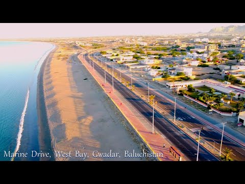
Stretching along the Arabian Sea for approximately 26 kilometers, Gwadar Marine Drive is the city’s most iconic urban artery—a palm-lined boulevard that blends coastal serenity with modern infrastructure. Designed as part of Gwadar’s transformation under the China-Pakistan Economic Corridor (CPEC), Marine Drive is both a leisure destination and a commercial lifeline, offering travelers panoramic sea views, cultural landmarks, and investment opportunities.
Urban Design and Layout
Marine Drive runs parallel to Gwadar Beach, connecting key zones of the city—from the Gwadar Port and Central Business District to residential neighborhoods and recreational parks. The road features:
- Multiple lanes for smooth traffic flow
- Street lighting and landscaped medians
- Pedestrian walkways and cycling paths
- Floodlights along the beach for nighttime visibility
The boulevard is flanked by emerging commercial plots, hotels, and public spaces, making it a focal point for both tourism and urban development.
Scenic and Recreational Appeal
Marine Drive is one of the most photogenic stretches in Balochistan. The road hugs the coastline, offering uninterrupted views of the sea, cliffs, and fishing boats. Key recreational spots along the drive include:
- GDA Beach Model Park: A landscaped park with seating, play areas, and sea views
- GDA Sunset Park: Ideal for evening strolls and photography
- Padizer Park: A quieter green space near the port
- Public Viewing Decks: Located near Koh-e-Batil and the Pearl Continental Hotel
Visitors can enjoy walking, jogging, cycling, or simply relaxing by the water. The area is especially popular during sunrise and sunset, when the light transforms the landscape into a painter’s palette.
Activities and Experiences
Marine Drive offers a range of experiences for travelers:
- Beach Walks: Stroll along the shore and watch fishermen at work
- Photography: Capture the interplay of sea, sky, and urban design
- Street Food: Sample local snacks from vendors along the boulevard
- Cultural Events: Attend festivals, poetry readings, and community gatherings
- Investment Tours: Explore commercial plots and real estate opportunities
The drive is also a popular route for car rallies, cycling events, and public parades, especially during national holidays and cultural celebrations.
Accessibility and Amenities
Marine Drive is centrally located and easily accessible:
- From Gwadar Airport: 20–25 minutes by car
- From Gwadar Port: 5–10 minutes
- By Rickshaw or Taxi: Widely available; fares range from PKR 200–500
- Parking: Available near parks, hotels, and public areas
Amenities include restrooms, shaded seating, food stalls, and security patrols. The road is well-lit and safe for evening visits.
- Best time to visit: October to March for cooler weather and clear skies
- Entry fees: None
- Safety tips: Stay on designated paths; avoid swimming in unmonitored zones
Photography Tips
- Golden Hour: Capture warm tones on the water and buildings
- Wide-Angle Shots: Frame the road, sea, and skyline together
- Night Photography: Use long exposure to capture floodlit beach scenes
- Drone Views: With permission, aerial shots reveal the full curve of the coastline
Marine Drive’s symmetry and natural lighting make it ideal for both landscape and architectural photography.
Cultural and Economic Significance
Marine Drive is more than a road—it’s a symbol of Gwadar’s aspirations. It connects the city’s past as a fishing village to its future as a global port and tourist destination. The boulevard is often featured in promotional materials, documentaries, and travel blogs as a visual representation of Gwadar’s transformation.
The area is also a hotspot for real estate investment, with commercial plots, hotels, and mixed-use developments underway. Projects like the proposed Chand-Taara Island—a man-made island shaped like Pakistan’s crescent and star—are planned just off Marine Drive, further enhancing its strategic value.
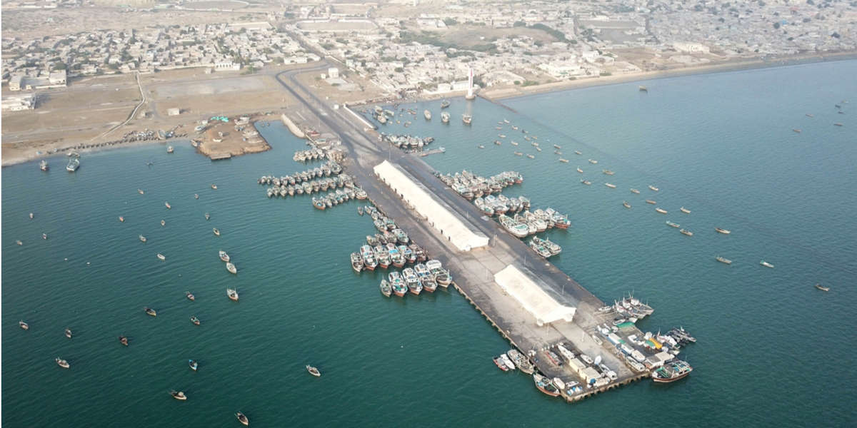
Gwadar Fish Harbour
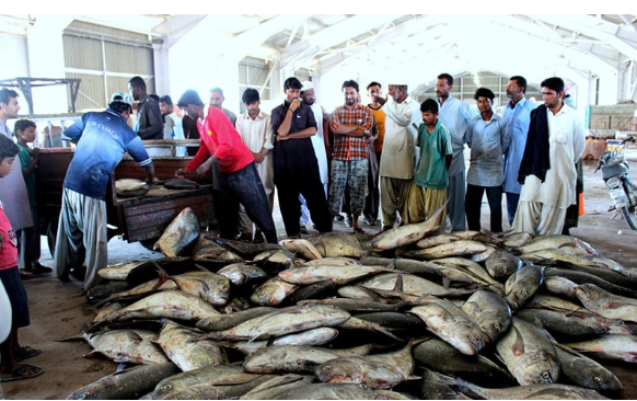
Tucked along the eastern edge of Gwadar’s coastline, Gwadar Fish Harbour is where the city’s soul meets the sea. Long before Gwadar became a strategic port city, it was a fishing village—and this harbour remains a living testament to that legacy. With its colorful boats, bustling docks, and salty air, the fish harbour offers travelers a raw, authentic glimpse into the daily life of coastal Balochistan.
Historical and Economic Significance
Gwadar Fish Harbour was formally constructed between 1988 and 1992 by the Belgian firm BESIX, under a turnkey contract awarded by the Government of Pakistan. Initially envisioned as a “fish harbour cum mini port,” the facility was part of early efforts to modernize Gwadar’s maritime infrastructure. Today, it is operated by the Federal Ministry of Communication and plays a key role in Pakistan’s fisheries sector.
The harbour supports thousands of livelihoods—from fishermen and boat builders to ice suppliers and seafood traders. It’s one of the busiest fish landing sites in Balochistan, handling species such as:
- Tuna
- Mackerel
- Shrimp
- Squid
- Lobster
- Sardines
The catch is sold locally and exported to markets in Karachi, the Middle East, and Southeast Asia.
Visual and Cultural Appeal
The harbour is a sensory experience:
- Sight: Rows of wooden boats painted in bright blues, reds, and greens bobbing in the water
- Sound: The chatter of fishermen, the hum of engines, and the squawk of seabirds
- Smell: A mix of saltwater, diesel, and fresh seafood
Visitors can watch boats unload their catch, observe fish auctions, and interact with local workers. The harbour is especially lively at dawn, when the day’s first catch arrives and the market springs to life.
Activities and Experiences
Gwadar Fish Harbour offers a range of immersive experiences:
- Boat Watching: Observe traditional fishing vessels known as dhows and launches
- Photography: Capture candid scenes of maritime life and dockside activity
- Seafood Sampling: Try freshly grilled fish or shrimp from nearby stalls
- Cultural Interaction: Engage with fishermen and learn about their techniques, stories, and challenges
While formal tours are rare, local guides and hotel staff can help arrange visits and explain the harbour’s operations.
Accessibility and Amenities
The harbour is located near Gwadar East Bay, just a short drive from the city center:
- By Rickshaw or Taxi: 10–15 minutes from Marine Drive; fares range from PKR 200–400
- By Foot: Possible from nearby neighborhoods
- Parking: Available near the entrance and along adjacent streets
Amenities include food stalls, shaded seating, and basic restrooms. Visitors should bring water, sun protection, and wear closed shoes due to wet and uneven surfaces.
- Best time to visit: Early morning (6–9 AM) for peak activity
- Entry fees: None
- Safety tips: Stay clear of active loading zones; ask permission before taking close-up photos
Photography Tips
- Golden Hour: Capture warm light on boats and water
- Detail Shots: Focus on nets, fish crates, and boat textures
- Portraits: With consent, photograph fishermen at work
- Action Shots: Use fast shutter speeds to capture unloading and auctions
Drone photography may be permitted with local approval, especially for wide shots of the harbour and surrounding coastline.
Cultural and Environmental Considerations
The harbour is a cultural anchor for Gwadar’s fishing communities. Generations of families have worked these waters, passing down skills, songs, and stories. Festivals like Eid and Baloch Cultural Day often include maritime rituals and boat decorations.
However, the harbour faces challenges:
- Overfishing and declining stocks
- Plastic pollution and waste management
- Climate change impacts on marine ecosystems
Local NGOs and government agencies are working to promote sustainable fishing practices, improve cold storage facilities, and support community resilience.
Buzi Pass
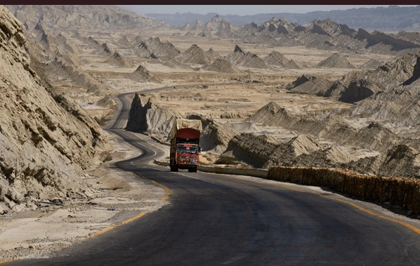
Carved into the rugged terrain of the Lasbela District, Buzi Pass is a winding mountain corridor that connects travelers to Gwadar via the Makran Coastal Highway. With its serpentine roads, towering cliffs, and panoramic vistas, Buzi Pass is more than a transit route—it’s a destination in itself. Whether you’re a road tripper, photographer, or history enthusiast, this pass offers a breathtaking journey through one of Balochistan’s most scenic landscapes.
Geographical and Visual Appeal
Buzi Pass sits at an elevation of approximately 68 meters, west of Gomazi Kaur and the Malkani Loop. As you ascend through the pass, the landscape unfolds dramatically—on one side, the coastal semi-desert stretches toward the horizon; on the other, jagged hills rise like ancient sentinels. The road curves along natural rock formations, offering uninterrupted views of the Hingol National Park in the distance.
The terrain is marked by:
- Natural carvings sculpted by wind and erosion
- Volcanic rock layers that hint at the region’s geological past
- Desert flora like acacia and wild shrubs
- Wildlife sightings, including foxes, ibex, and migratory birds
Buzi Pass is especially captivating during sunrise and sunset, when the light casts golden hues across the cliffs and valleys.
Historical Significance
Buzi Pass is steeped in history. It is believed that Alexander the Great traversed this region during his return from the Indus Valley campaign. Historical accounts suggest that his army suffered significant losses while navigating the harsh terrain of the Makran coast. This connection adds a layer of intrigue to the pass, making it a point of interest for historians and cultural travelers.
Local folklore also references Buzi Pass as a spiritual corridor, with tales of ancient caravans, mystics, and tribal gatherings echoing through its valleys.
Activities and Experiences
Buzi Pass offers a range of experiences for travelers:
- Scenic Driving: Cruise along the Makran Coastal Highway and enjoy cinematic views
- Photography: Capture dramatic landscapes, winding roads, and desert silhouettes
- Hiking: Explore side trails and rock formations for a closer look at the terrain
- Nature Observation: Spot wildlife and desert flora in their natural habitat
- Cultural Exploration: Engage with roadside communities and learn about local legends
The pass is a favorite among motorcyclists, overlanders, and travel bloggers for its raw beauty and road trip appeal.
Accessibility and Travel Tips
Buzi Pass is located approximately:
- 300 km west of Karachi
- 120 km east of Gwadar
- Near Pasni town, making it a midpoint stop for coastal travelers
- By car: Accessible via the Makran Coastal Highway; road conditions are excellent
- By bus: Luxury coaches like Al Saeed and Al Mumtaz pass through this route
- By bike: Popular among adventure riders and cycling groups
- Best time to visit: October to March for cooler temperatures and clear skies
- Safety tips: Drive cautiously around blind curves; avoid travel during heavy rain or fog
- Essentials: Carry water, snacks, fuel, and a camera; mobile coverage may be limited
There are no formal rest stops within the pass, but nearby towns like Ormara and Pasni offer food, fuel, and lodging.
Photography Tips
- Wide-Angle Shots: Frame the road against cliffs and desert plains
- Golden Hour: Capture warm tones and long shadows across the pass
- Drone Views: With permission, aerial shots reveal the full curvature of the highway
- Detail Shots: Focus on rock textures, erosion patterns, and desert flora
Buzi Pass’s natural lighting and elevation changes make it ideal for both landscape and travel photography.
Cultural and Symbolic Value
For locals, Buzi Pass is a symbol of resilience and connection. It links remote communities to urban centers and serves as a lifeline for trade, travel, and storytelling. The pass is often referenced in Balochi poetry and songs as a metaphor for journey, endurance, and transformation.
During national holidays and cultural festivals, the highway becomes a ribbon of celebration—decorated vehicles, roadside gatherings, and music echoing through the hills.
Princess of Hope
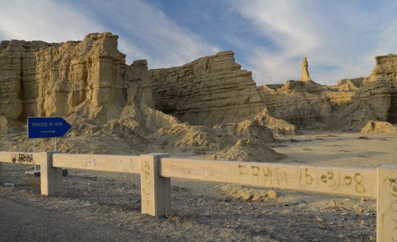
Standing tall and solitary in the rugged expanse of Hingol National Park, the Princess of Hope is a breathtaking natural rock formation that resembles a regal figure gazing across the desert. Sculpted by centuries of wind erosion, this geological marvel has captured the imagination of travelers, photographers, and cultural storytellers alike. It’s not just a rock—it’s a symbol of resilience, mystery, and the timeless artistry of nature.
Location and Geological Formation
The Princess of Hope is located in the Lasbela District of Balochistan, approximately 190 kilometers west of Karachi and 717 kilometers southeast of Quetta, along the Makran Coastal Highway. The formation is part of a series of hoodoos—also known as “fairy chimneys”—created by the natural forces of wind and rain over thousands of years.
The figure stands upright, with a crown-like top and flowing contours that resemble a skirted female form. It’s a textbook example of mimetolith, where natural rock formations appear to mimic living shapes.
Naming and Cultural Significance
The name “Princess of Hope” was coined in 2002 by Angelina Jolie, who visited Hingol National Park as a UN Goodwill Ambassador. Struck by the statue’s elegance and solitary stance, she named it as a symbol of hope for the people of Balochistan. The name resonated deeply and quickly became part of local lore.
Today, the Princess is not only a tourist attraction but also a cultural emblem—featured in poetry, art, and regional storytelling. It’s often paired with the nearby Balochistan Sphinx, another naturally formed rock structure that resembles a lion or sphinx.
Activities and Experiences
Visiting the Princess of Hope is a journey through both landscape and legend:
- Sightseeing: Marvel at the rock’s uncanny resemblance to a human figure
- Photography: Capture dramatic desert scenes and sculptural textures
- Hiking: Explore the surrounding terrain and nearby formations
- Cultural Exploration: Learn about local myths and the site’s spiritual resonance
The area is remote and lacks commercial infrastructure, so visitors should come prepared for a rugged, self-guided experience.
Accessibility and Travel Tips
To reach the Princess of Hope:
- Route: Drive along the Makran Coastal Highway from Karachi toward Gwadar
- Distance: Approximately 190 km from Karachi; 4–5 hours by car
- Nearest town: Ormara, which offers basic amenities and fuel
- Road conditions: Excellent highway with scenic views; limited signage near the site
- Best time to visit: October to March for cooler temperatures and clear skies
- Essentials: Bring water, snacks, sunblock, trekking shoes, and a camera
- Safety tips: Avoid travel during monsoon season; stay on marked paths
There are no restrooms or food stalls at the site, so plan accordingly. Guided tours are available through select travel agencies in Karachi and Gwadar.
Photography Tips
- Golden Hour: Capture warm tones on the rock and desert floor
- Wide-Angle Shots: Frame the Princess against the vast sky and cliffs
- Detail Shots: Focus on erosion patterns and textures
- Drone Views: With permission, aerial shots reveal the full landscape and nearby formations
The Princess’s silhouette is especially striking at sunrise and sunset, when shadows enhance its sculptural depth.
Conservation and Environmental Considerations
As a natural monument, the Princess of Hope is vulnerable to:
- Human interference: Graffiti, littering, and off-road driving
- Climate change: Increased erosion and temperature extremes
- Tourism pressure: Lack of formal management and visitor facilities
Local NGOs and park authorities are working to promote eco-tourism and responsible travel. Visitors can support these efforts by practicing Leave No Trace principles and sharing awareness.
Climate and Weather in Gwadar
Gwadar’s climate is defined by its coastal geography and desert terrain, resulting in a subtropical desert climate (Köppen classification: BWh). With long, hot summers and mild winters, the city experiences minimal rainfall and abundant sunshine year-round. Understanding Gwadar’s weather patterns is essential for planning travel, outdoor activities, and investment visits.
Annual Climate Overview
- Average annual temperature: 26.84°C (80.31°F)
- Annual high temperature: 30.95°C (87.71°F)
- Annual low temperature: 18.8°C (65.84°F)
- Average annual precipitation: 13.73 mm (0.54 inches)
- Rainy days per year: 26.86 days (7.36% of the year)
- Humidity: Average 23.7%; lowest in June (12.74%)
Gwadar is dry for over 92% of the year, with most rainfall concentrated in winter months. The city’s elevation—674 meters above sea level—moderates extreme heat and contributes to its breezy coastal conditions.
Seasonal Breakdown
Summer (May to September)
Gwadar’s summer is long, dry, and intensely sunny.
- Peak temperatures: July averages 43.14°C (109.65°F); record high 48.72°C (119.7°F)
- Humidity: Drops to 12–18%, creating dry heat
- Rainfall: Minimal; July sees only 1.24 mm on average
- Sunshine: Up to 14.57 hours/day in June and July
Outdoor activities should be scheduled for early morning or late evening. Hydration and sun protection are essential.
Autumn (October to November)
Temperatures begin to drop, and conditions become ideal for travel.
- Average highs: 31.68°C in October, 23.67°C in November
- Rainfall: Light, with 2.84 mm in October and 16.35 mm in November
- Humidity: Rises to 30–31%
This is a prime season for sightseeing, photography, and cultural events.
Winter (December to February)
Gwadar’s winter is mild and dry, with cool nights and pleasant days.
- Coldest month: January, with lows around 6.79°C (44.22°F)
- Rainfall: February is the wettest month (42 mm)
- Humidity: Peaks at 36–39%
- Sunshine: 8.9 to 11.6 hours/day
Ideal for hiking, port visits, and exploring inland attractions like Buzi Pass.
🌱 Spring (March to April)
Spring brings warming temperatures and occasional showers.
- Average highs: 26.41°C in March, 32.78°C in April
- Rainfall: Moderate, with 36.31 mm in March and 21.62 mm in April
- Humidity: Drops to 22–29%
This season is excellent for marine activities, including snorkeling and boat tours.
Monthly Climate Snapshot
| Month | Avg High (°C) | Avg Low (°C) | Rainfall (mm) | Humidity (%) | Sunshine (hrs/day) |
|---|---|---|---|---|---|
| January | 17.3 | 6.79 | 23.91 | 39.78 | 10.63 |
| April | 32.78 | 21.64 | 21.62 | 22.52 | 12.14 |
| July | 43.14 | 28.66 | 1.24 | 17.92 | 14.57 |
| October | 31.68 | 17.89 | 2.84 | 19.59 | 11.75 |
| December | 18.25 | 7.5 | 3.76 | 31.32 | 9.14 |
Wind and Coastal Conditions
- Prevailing winds: Southwest, especially during summer
- Average wind speed: Mild, with occasional gusts near the coast
- Sea temperature: Ranges from 25°C to 29°C, ideal for swimming April–December
Climate-Related Travel Tips
- 🧴 Sun Protection: Use SPF 50+, sunglasses, and hats year-round
- 💧 Hydration: Carry water, especially during hikes or port visits
- 🕶️ Timing: Avoid outdoor exposure between 12–4 PM in summer
- 🧥 Winter Gear: Light jackets for evenings in December–February
- 🌊 Marine Planning: Check tide charts and wind forecasts before boating
TL;DR: Gwadar is hot, dry, and sunny most of the year, with brief, mild winters and minimal rainfall. October to March offers the most comfortable conditions for travel, sightseeing, and outdoor exploration. Summer is extremely hot and dry, ideal only for early morning or indoor activities.
Best Visiting Periods in Gwadar
Gwadar’s appeal lies in its year-round sunshine, coastal serenity, and cultural depth—but timing your visit can make the difference between a comfortable adventure and a heat-stricken struggle. With its subtropical desert climate, Gwadar is best experienced during the cooler months, when temperatures are mild, skies are clear, and cultural life is vibrant.
Ideal Travel Window: September to March
According to regional tourism experts, the most favorable time to visit Gwadar is between September and March, when the weather is cooler and the low tide season enhances beach accessibility. During this period:
- Daytime temperatures range from 18°C to 28°C
- Humidity is moderate, making outdoor activities pleasant
- Sunshine averages 10–12 hours/day
- Rainfall is minimal, except for light showers in February
This window is perfect for sightseeing, photography, hiking, and marine excursions. It also aligns with Gwadar’s cultural calendar, offering travelers a chance to engage with local traditions.
Month-by-Month Breakdown
| Month | Travel Rating | Highlights | Notes |
|---|---|---|---|
| September | 🟢 Excellent | Low tide season begins; ideal for beach walks | Warm but manageable |
| October | 🟢 Excellent | Clear skies; perfect for photography | Start of peak season |
| November | 🟢 Excellent | Cultural events and mild weather | Ideal for sightseeing and hiking |
| December | 🟡 Good | Coolest month; great for port and inland visits | Nights can be chilly |
| January | 🟡 Good | Crisp mornings; fewer crowds | Light jackets recommended |
| February | 🟡 Good | Slight rainfall; lush landscapes | Best for nature lovers |
| March | 🟢 Excellent | Warm days; cultural festivals | Adventure tourism thrives |
| April | 🟡 Moderate | Rising heat; early morning activities advised | Avoid midday exposure |
| May–August | 🔴 Challenging | Extreme heat; limited outdoor comfort | Suitable only for seasoned travelers |
Cultural and Festival Calendar
Aligning your visit with local events adds depth to your experience. Key observances include:
- Baloch Cultural Day (March 2): Celebrated with music, poetry, and traditional dress
- Eid al-Fitr & Eid al-Adha (dates vary): Festive markets, communal meals, and spiritual gatherings
- Fishing Season Peaks (October–March): Ideal for seafood lovers and harbor visits
- Winter Stargazing (December–February): Clear skies make Gwadar perfect for astrophotography
Note: Islamic festivals follow the lunar calendar and shift annually. Confirm dates with local sources before planning.
Travel Planning Tips
- Book Early: Hotels and transport fill up quickly during peak months
- Pack Smart: Include sunblock, light layers, and hydration gear
- Stay Informed: Check tide charts and weather forecasts before beach or boat activities
- Engage Locally: Visit markets, attend poetry gatherings, and explore tribal customs
Don’t Forget: If you want to experience Gwadar at its most welcoming—weather-wise and culturally—plan your trip between October and March. You’ll enjoy cooler temperatures, vibrant festivals, and full access to the city’s natural and historical treasures.
Local Cuisine in Gwadar
Gwadar’s culinary landscape is a flavorful reflection of its coastal geography, Balochi heritage, and maritime economy. Meals here are simple yet rich, often centered around fresh seafood, slow-cooked meats, and traditional breads. Whether you’re dining at a roadside stall or a seaside restaurant, Gwadar offers a sensory experience rooted in authenticity and community.
Traditional Dishes of Gwadar
Here are some of the most iconic dishes you’ll encounter:
- Sajji: Whole lamb or chicken marinated in salt and roasted over open flames. Served with Kaak (stone-baked bread) or rice.
- Dumpukht: Slow-cooked meat sealed in a pot to retain juices and flavor.
- Kaak: Hard, flat bread baked on hot stones, often paired with meat or yogurt.
- Khaddi Kabab: Lamb stuffed and cooked underground, reserved for tribal gatherings.
- Tereeth: Roti pieces mixed with curry and Khrud (dry salty yogurt).
- Laandhi: Preserved meat cured over months and cooked with spices.
- Abgoosht: A lamb stew with beans and mashed vegetables, influenced by Persian cuisine.
- Roosh: Lamb joints served with broth and lentils.
- Butt o Maash: A mix of pulses, served sweet or salty.
- Chilaanch: A layered dessert made with kheer and jelly, eaten with roti and onions.
- Fried Fish Sajji: Coastal-style fish grilled with minimal seasoning.
Meals are typically accompanied by Lassi, Chai, and seasonal fruits like dates, pomegranates, and mangoes.
Top Restaurants in Gwadar
Here’s a curated list of 50 restaurants, cafes, and food stalls in Gwadar, categorized by cuisine type, price range, and location.
| Name | Cuisine Type | Price Range | Location | Contact |
|---|---|---|---|---|
| Al Rehman Restaurant | Pakistani | $ | Airport Road, Gwadar | 0333-3156688 |
| Gwadar Fish Point | Seafood | $$ | Marine Drive | 0332-8084682 |
| Baloch Sajji House | Traditional | $ | Old Town Gwadar | 0333-7974601 |
| PC Gwadar Restaurant | Continental | $$$ | Koh-e-Batil | 0864-210001 |
| Baba Hotel | Mixed Cuisine | $ | Jinnah Avenue | 0336-0355681 |
| Gwadar Biryani Center | Pakistani | $ | Central Bazaar | 0333-7337235 |
| Gwadar BBQ Spot | BBQ | $$ | Near Fish Harbour | 0333-2723821 |
| Marine Drive Café | Snacks/Tea | $ | Marine Drive | 0323-2660066 |
| Al Saeed Restaurant | Pakistani | $$ | Port Road | 0335-0325015 |
| Gwadar Ice Cream Corner | Desserts | $ | Near Sunset Park | 0333-2278900 |
| Gwadar Tea House | Tea/Desserts | $ | Near City Park | 0335-7571394 |
| Baloch Tandoor | Breads/BBQ | $ | Near Railway Quarters | — |
| Gwadar Pizza Point | Fast Food | $$ | Near College Road | — |
| Gwadar Family Restaurant | Mixed Cuisine | $$ | Near City Hospital | — |
| Gwadar Breakfast Café | Breakfast | $ | Near Market Square | — |
| Gwadar Grill & Dine | BBQ/Continental | $$ | Near Commissioner Road | — |
| Gwadar Cultural Café | Traditional | $$ | Near Nazim’s Mosque | — |
| Gwadar Mango Orchard Café | Organic/Local | $$ | Near Pasni Road | — |
| Gwadar Student Food Center | Fast Food | $ | Near College Road | — |
| Gwadar Baloch Cuisine House | Traditional | $$ | Near Shahi Tump | — |
| Gwadar Continental Inn | Continental | $$ | Near University Campus | — |
| Gwadar BBQ Express | BBQ | $$ | Near Port Area | — |
| Gwadar Family Tandoor | Breads/BBQ | $ | Near Railway Quarters | — |
| Gwadar Orchard Inn | Farm Stay Dining | $$ | Kech Valley | — |
| Gwadar Veg Delight | Vegetarian | $ | Near College Road | — |
| Gwadar Curry Junction | Curry Dishes | $ | Near Absor Town | — |
| Gwadar Baloch Food Plaza | Mixed Cuisine | $$ | Near University Road | — |
| Gwadar Eco Café | Organic/Local | $$ | Near Kech River | — |
| Gwadar Tandoori House | Breads/BBQ | $ | Near Shahi Tump | — |
| Gwadar Street Food Hub | Mixed Snacks | $ | Central Bazaar | — |
| Gwadar Fish Fry | Seafood | $ | Near Riverbank | — |
| Gwadar Cultural Inn | Traditional | $$ | Near Shahi Tump | — |
| Gwadar Park Café | Continental | $$ | Near City Park | — |
| Gwadar Comfort Inn | Mixed Cuisine | $$ | Near City Hospital | — |
| Gwadar Sunset Restaurant | Seafood/BBQ | $$ | Near Sunset Park | — |
| Gwadar Tikka Point | BBQ | $ | Near Eid Gah | — |
| Gwadar Veg Corner | Vegetarian | $ | Near Market Square | — |
| Gwadar Food Street | Street Food | $ | Central Bazaar | — |
| Gwadar Orchard Stay | Farm Dining | $$ | Kech Valley | — |
| Gwadar Comfort Residency | Mixed Cuisine | $$ | Bolan Colony | — |
| Gwadar Backpacker Café | Snacks/Tea | $ | Near College Road | — |
| Gwadar Mango Grove Lodge | Farm Stay | $$ | Naal Valley | — |
| Gwadar Guest House Café | Local Cuisine | $ | Near Market Square | — |
| Gwadar Tea & Talk Café | Tea/Desserts | $ | Near City Library | — |
| Gwadar Veg Delight | Vegetarian | $ | Near College Road | — |
| Gwadar Curry House | Curry Dishes | $ | Near Absor Town | — |
| Gwadar Baloch Food Plaza | Mixed Cuisine | $$ | Near University Road | — |
| Gwadar Eco Café | Organic/Local | $$ | Near Kech River | — |
| Gwadar Tandoori House | Breads/BBQ | $ | Near Shahi Tump | — |
Accommodation in Gwadar
Gwadar’s hotel scene is steadily expanding, offering a mix of budget guesthouses, mid-range motels, and premium resorts. While the city is still developing its tourism infrastructure, travelers can find clean, comfortable, and locally managed places to stay—many with stunning sea views and proximity to key attractions like Marine Drive, Gwadar Port, and Koh-e-Batil.
Types of Accommodation
- Luxury Hotels: Ideal for business travelers and high-end tourists. These offer full amenities including pools, restaurants, and security.
- Mid-Range Motels: Comfortable rooms with basic services, often near commercial zones or transport hubs.
- Budget Guesthouses: Affordable options for solo travelers, students, and backpackers.
- Family Lodges: Spacious rooms and local hospitality, often run by Baloch families.
- Business Centers: Designed for short-term stays with meeting rooms and Wi-Fi.
Most hotels operate on a walk-in basis, but online booking is available through platforms like , , and .
Top Hotels in Gwadar
| Hotel Name | Price Range | Amenities | Location | Rating (if available) |
|---|---|---|---|---|
| Zaver Pearl Continental Hotel | $$$ | Pool, Wi-Fi, Restaurant, Gym | Koh-e-Batil | 4.1★ |
| Gwadar Tourist Motel | $$ | Local Cuisine, Sea View, Parking | Near Marine Drive | 4.5★ |
| Sadaf Resort | $$ | Renovated Rooms, Breakfast | Central Gwadar | 3.8★ |
| Gwadar Business Center | $$ | Meeting Rooms, Wi-Fi | Port Road | — |
| Sahil Guest House | $ | Basic Rooms, Local Meals | Near Fish Harbour | — |
| Al Salam Hotel Guest House | $ | Shared Kitchen, Parking | Jinnah Avenue | — |
| Royal Resort | $$ | Family Rooms, Garden | Near Sunset Park | — |
| Gwadar Palace Hotel | $$ | AC, Restaurant, Wi-Fi | Near City Hospital | — |
| Askani Hotel | $ | Budget Rooms, Local Cuisine | Old Town Gwadar | — |
| KTown Rooms | $$ | Near Marine Drive, Wi-Fi | Marine Drive | — |
| Gwadar Comfort Inn | $$ | AC, Wi-Fi, Room Service | Near City Library | — |
| Gwadar Sunset Lodge | $$ | Scenic Views, Garden | Near Sunset Park | — |
| Gwadar Eco Lodge | $$ | Solar Power, Organic Meals | Kech Valley | — |
| Gwadar Heritage Stay | $$ | Cultural Decor, Local Cuisine | Near Shahi Tump | — |
| Gwadar Transit Inn | $ | Basic Rooms, Tea Service | Near Bus Terminal | — |
| Gwadar Boutique Hotel | $$ | Stylish Decor, Wi-Fi | Near Market Square | — |
| Gwadar Central Hotel | $$ | Wi-Fi, Breakfast, Laundry | Central Bazaar | — |
| Gwadar Mango Orchard Stay | $$ | Farm Stay, Organic Meals | Naal Valley | — |
| Gwadar Youth Hostel | $ | Dorms, Shared Kitchen | Near College Road | — |
| Gwadar Family Inn | $$ | Family Suites, Wi-Fi | Near City Hospital | — |
| Gwadar Guest Residency | $$ | AC, Parking, Breakfast | Near Market Square | — |
| Gwadar Backpacker Inn | $ | Dorms, Shared Lounge | Near College Road | — |
| Gwadar Park Hotel | $$ | AC, Garden, Wi-Fi | Near City Park | — |
| Gwadar Riverside Stay | $$ | River Views, Breakfast | Near Kech River | — |
| Gwadar Cultural Inn | $$ | Traditional Decor, Local Food | Near Shahi Tump | — |
| Gwadar Budget Inn | $ | Basic Rooms, Shared Bathroom | Near Bus Terminal | — |
| Gwadar Orchard Retreat | $$ | Farm Stay, Local Cuisine | Kech Valley | — |
| Gwadar Comfort Residency | $$ | AC, Wi-Fi, Room Service | Bolan Colony | — |
| Gwadar Business Lodge | $$ | Meeting Rooms, Wi-Fi | Near Commissioner Road | — |
| Gwadar Family Stay | $$ | Family Rooms, Kitchenette | Near City Hospital | — |
| Gwadar Mango Grove Lodge | $$ | Farm Stay, Organic Meals | Naal Valley | — |
| Gwadar Guest House | $ | Basic Rooms, Local Food | Near Market Square | — |
| Gwadar Pearl View Hotel | $$ | Sea View, Restaurant, Wi-Fi | Near Koh-e-Batil | — |
| Gwadar Horizon Motel | $$ | Rooftop Dining, AC | Near Port Road | — |
| Gwadar Seaside Residency | $$ | Balcony Views, Breakfast | Marine Drive | — |
| Gwadar Marina Guest House | $$ | Near Harbour, Local Meals | Near Fish Harbour | — |
| Gwadar Tandoor Guesthouse | $ | Shared Rooms, Local Meals | Near Railway Quarters | — |
| Gwadar Orchard Inn | $$ | Farm Views, Local Breakfast | Kech Valley | — |
| Gwadar Backpacker Café | $ | Shared Lounge, Tea Service | Near College Road | — |
| Gwadar Veg Delight Lodge | $ | Vegetarian Meals, Budget Rooms | Near College Road | — |
| Gwadar Curry House Motel | $ | Curry Dishes, Basic Rooms | Near Absor Town | — |
| Gwadar Baloch Food Plaza Stay | $$ | Mixed Cuisine, AC | Near University Road | — |
| Gwadar Eco Stay | $$ | Organic Meals, Solar Power | Near Kech River | — |
| Gwadar Tandoori House Lodge | $ | Breads/BBQ, Shared Rooms | Near Shahi Tump | — |
| Gwadar Street View Inn | $ | Budget Rooms, Local Snacks | Central Bazaar | — |
| Gwadar Fish Harbour Motel | $$ | Seafood Dining, Port Views | Near Fish Harbour | — |
| Gwadar Cultural Residency | $$ | Traditional Decor, Local Cuisine | Near Shahi Tump | — |
| Gwadar Park Residency | $$ | AC, Garden, Wi-Fi | Near City Park | — |
Frequently Asked Questions (FAQs)
1. Do I need a No Objection Certificate (NOC) to visit Gwadar?
Yes, if you’re a foreign national, you’ll need a No Objection Certificate (NOC) to travel to Gwadar and other parts of Balochistan. This is separate from your visa and must be arranged in advance through a registered travel agency or your country’s embassy in Pakistan. Pakistani citizens do not require a NOC.
2. Is Gwadar safe for tourists?
Gwadar is generally safe for domestic travelers and guided foreign visitors. The city has a strong security presence due to its strategic importance. However, it’s recommended to:
- Travel with a local guide or agency
- Avoid isolated areas after dark
- Stay updated on local advisories
- Inform your accommodation of your itinerary
3. What is the best way to reach Gwadar?
Gwadar is accessible via:
- Air: Gwadar International Airport (GWD) offers flights from Karachi, Islamabad, and Turbat
- Road: The Makran Coastal Highway connects Gwadar to Karachi (8–9 hours by car)
- Bus: Luxury coaches like Al Saeed and Al Mumtaz operate daily routes
- Sea: No passenger ferry service yet, but private vessels may dock with permission
4. What languages are spoken in Gwadar?
The primary languages are:
- Balochi
- Brahui
- Urdu (widely understood)
- English (spoken in hotels, businesses, and government offices)
Learning a few Balochi phrases is appreciated and can enhance your experience.
5. What should I wear in Gwadar?
Modest clothing is recommended:
- Men: Shalwar kameez or long pants and shirts
- Women: Loose-fitting clothes with a headscarf, especially in rural or religious areas
Light fabrics are ideal due to the heat. Swimwear should be reserved for private beach areas.
6. Are there ATMs and mobile networks available?
Yes:
- ATMs: Available in central areas; cash is preferred in markets and small eateries
- Mobile networks: Jazz, Zong, Ufone, and Telenor operate in Gwadar; coverage may be limited in remote zones
7. Can I use credit cards?
Credit card acceptance is limited. Most transactions are cash-based. Some hotels and upscale restaurants may accept cards—confirm in advance.
8. What are the cultural norms I should be aware of?
- Greet elders respectfully
- Avoid public displays of affection
- Ask before photographing people
- Remove shoes before entering homes or mosques
- Accepting tea or snacks is considered polite
Hospitality is central to Baloch culture—visitors are often treated as honored guests.
9. What kind of power outlets are used?
Pakistan uses:
- Type C and Type D plugs
- Voltage: 230V
- Frequency: 50Hz
Carry a universal adapter and voltage converter if needed.
10. Is Gwadar suitable for solo travelers?
Yes, especially for domestic tourists and researchers. Solo travelers should:
- Stay in central areas
- Avoid isolated routes
- Connect with local guides or hosts
- Register with their embassy if staying long-term
11. Can I visit religious sites as a non-Muslim?
Yes, with respect and discretion. Sites like the Shrine of Baba Chand welcome visitors outside of prayer times. Always ask for permission before entering prayer halls or taking photos.
12. What are emergency contacts in Gwadar?
- Police: 15
- Ambulance: 1122
- Fire Brigade: 16
- Civil Hospital Gwadar: Near Jinnah Avenue
- Local Administration Office: Near Marine Drive
Keep a copy of your passport, visa, and NOC (if applicable) at all times.


